|
|
Class: BIVALVIA
--- Taxon Tree: PALAEOHETERODONTA [Subclass] - UNIONIDA [Order] - UNIONOIDEA [Superfamily]
------ Family: UNIONIDAE Rafinesque, 1820 (Freshwater)
--------- SubFamily: AMBLEMINAE
------------ Genus: Lampsilis C.S. Rafinesque, 1820
|
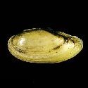
--------------- Species: Lampsilis teres C.S. Rafinesque, 1820 - ID: 5537900170
|
|
|
|
synonyms: |
|
Lampsilis anodontoides I. Lea, 1834
| |
|
Additional DB records: |
Tennessee - 80 mm
Alabama, Catawba River
|
Alabama, Crenshaw County, Patsaliga Creek
| | |
Alabama, Maringo, Prairie Creek
Arkansas, Lake Chicot, Chicot County
|
Darien
| | |
Florida, Holmes County, Choctawhatchee River
Florida, Leon County, Ochlockonee River
|
Illinois, Henderson County, Benton Slough
| | |
Iowa, Dickinson County, Little Sioux River
Iowa, Lee County, Keokuk, Mississippi River
|
Louisiana, Allen Parish, Calcasieu River
| | |
Louisiana, Pearl River, Washington Parish
Mississippi River
|
Mississippi, Pearl River County, Pearl River
| | |
Mississippi, Perry County, Leaf River
Tennessee
|
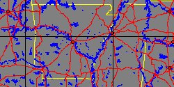
Tennessee, Hardin County, Tennessee River
| | |
Texas, Brazoria County, Brazos River
Texas, Gregg County, Sabine River
|
Texas, Hardin County, Menard Creek
| | |
Texas, Hardin County, Pine Island Bayou
Texas, La Salle County, Nueces River
|
Texas, Mason County, Art
| | |
Texas, Mcmullen County, Nueces River
Texas, Val Verde County, Pecos River
|
Texas, Zavala County, Nueces River
| | |
USA, Georgia, Chattahoochee County
USA, Georgia, Worth County
|
USA, Gulf Coast
| | |
Wisconsin, Crawford County, Prairie du Chien
|
Wisconsin, Wisconsin River, Sauk County
| | |
|
|
------------------ Sub or form: Lampsilis teres anodontoides C.S. Rafinesque, 1820 - ID: 5539751202
|
|
|
|
Additional DB records: |
|
Missouri, Mississippi River, probably between Canton, Mo
| |
|
|
------------------ Sub or form: Lampsilis teres fallaciosus C.S. Rafinesque, 1820 - ID: 7154000186
|
|
|
|
Additional DB records: |
|
Arkansas, Boeuf River, Chicot County
| |
|
|
|